American
Association of State Highway and Transportation Officials
Special
Committee on Research and Innovation
FY2023
NCHRP PROBLEM STATEMENT
Problem Number:
2023-G-25
Problem Title
A Study
of Spatio-temporal Traffic Patterns in Metropolitan Atlanta Using Google Maps
Background Information And Need For Research
Urbanization
and economic growth in the metro Atlanta region have caused heavy traffic
congestions on major roads. According to the 2019 Global Traffic Scorecard by
INRIX that was published in 2020, Atlanta is one of the top 10 most congested
cities in the United States before the pandemic. For intelligent transportation
systems and urban/transportation planning, it is necessary to identify temporal
and spatial traffic congestion patterns. Temporal traffic patterns may include,
but are not limited to, traffic durations and intensities during morning,
afternoon, evening, daytime, and nighttime. Spatial traffic patterns will also
tell where certain traffic patterns occur. The main drawback of studying
temporal and spatial traffic patterns has been the limitation of available data
resources, particularly from field sensors. This research proposes using online
traffic layers, like Google Traffic, as a major data source. This research is
directly related to the Goals 4 and 5 of “Strategic Plan for the Council on
Data Management & Analytics”, approved by the AASHTO Strategic Management
Committee on September 17, 2019. Particularly, this research will facilitate
the development and advancement of tools to support decision making data and
analytics needs (Goal 4.3) and support research to advance the development and
use of tools and best practices in communicating data, data management and
analytics (Goal 5.1)
Literature Search Summary
Analyzing
traffic patterns in a metropolitan area has been hampered significantly due to
the scarcity of field sensor data. At best, we could identify potential
congestion corridors using AADT and road design capacity (e.g., Seong, Kassa,
and Choi, 2011, doi: 10.1007/978-3-642-19214-2_30). Recently, crowd-sourced
datasets and online traffic maps, however, have opened a new horizon for
transportation research. They have been applied to various transportation
applications such as transportation policy research (Loop et al., 2019, DOI:
10.13140/RG.2.2.28893.05), congestion forecasting (Pramanik et al., 2020,
arXiv:2011.02359 [cs.CY]), traffic flow estimation (Baji, 2020, doi:
10.15201/hungeobull.67.1.5), and level of service calculation (Ali and Abid,
2021, doi:10.1088/1757-899X/1076/1/01201). Our literature search of TRID, RIP,
and academic journals, however, does not show any previous research about
identifying temporal and spatial traffic patterns in a metro city from
geographical perspectives. Our research will pioneer the temporal and spatial
aspects of traffic events by incorporating GIS (geographic information systems)
and big data analysis techniques.
Research Objective
The
objective of this research project is to identify temporal and spatial traffic
patterns in the metro Atlanta area. Traffic patterns will be analyzed at two
different geographical scales: one at the macro scale along the major roads in
the metro Atlanta and the other at the micro-scale along the interstate
highways. Major deliverables of this research are traffic patterns with the
information of when, where, and severity. A website will also be developed to
visualize traffic patterns interactively and to share them with Georgia DOT,
metro Atlanta MPO, and the public.
To
achieve the objective, we will construct a 3-D spatio-temporal data cube by
sampling Google Maps Traffic Layer every 10 minutes via the Google Maps API,
and we will identify temporal traffic patterns by clustering the 24-hour
traffic trends at sample points on roads. The following diagram (Figure 1)
shows eleven temporal traffic patterns that were derived from a one-day pilot
dataset, where the x-axis represents time of a day, and the y-axis represents
traffic severity. The inset map shows the extent of the metro Atlanta that were
used in the pilot study. In the figure the red line, for example, represents a
traffic pattern that has a light traffic in the morning and a very heavy
traffic in the afternoon from 3:00 pm to 7:30 pm. We will collect traffic data
for 20-weeks, at least, to avoid statistical biases. The optimal number of
traffic patterns will be identified, and various temporal traffic-vector
clustering techniques will be tested.
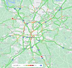
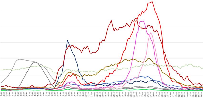
Figure 1.
Temporal traffic patterns identified from a one-day sample dataset
We will
also analyze the difference between weekdays and weekends. Various geospatial
data science techniques will be used such as GIS, Python libraries, R packages,
server-side programs like Javascript, and spatio-temporal data visualization
techniques. Lastly, we will develop an interactive online mapping application
using an online mapping platform such as ArcGIS Online. This research requires
extensive resources for 24/7 data acquisition, data post-processing, testing
multiple models, validating traffic patterns, visualizing outcomes, and writing
reports. Multiple student assistants and research associates will be hired for
this project.
Urgency and Potential Benefits
As the
population of the metro Atlanta area has increased dramatically, road traffic
has also increased significantly. Identifying traffic locations and patterns is
an important step for a reliable transportation planning. It, however, has been
impossible to analyze them for such a large area mainly because of the limited
number of field sensors. Utilizing online traffic layers can supplement field
sensors. This research will benefit transportation planners and urban planners
by providing them with traffic pattern types and their locations. The
methodologies that are developed in this research may benefit other state DOT’s
and MPO’s to analyze their endemic traffic patterns.
Implementation Considerations
The
research results of this project will be used by GDOT for implementing the
Statewide Transportation Plan (SWTP) and State Transportation Improvement
Program (STIP). The Atlanta Regional Commission (ARC), the MPO for metro
Atlanta, has recently researched various applications of the Google’s floating
car data for their long-term metropolitan transportation planning. This
research will support ARC’s transportation and commuting research with floating
car data by providing new perspectives about traffic patterns. Our research may
also benefit from ARC’s floating car data as a validation source. Research
findings will be presented at GDOT and ARC and will be submitted to academic
journals for publication.
Recommended Research Funding and Research
Period
We
propose three years to perform this research. Year 1 will collect data and
analyze traffic patterns on major roads of metro Atlanta, Year 2 will focus on
interstate highways in detail including their ramps and exits, and Year 3 will
implement an online mapping platform that allows interactive queries of traffic
patterns. University of West Georgia, Georgia Institute of Technology, Atlanta
Regional Commission, and GDOT will collaborate on this research. The annual
budget will be $298,750 that will include PI and co-PI salaries ($30,000),
institutional sub-award ($120,000), research associates ($60,000),
undergraduate student assistants ($24,000), supplies ($8,000), travel ($8,000),
and IDC 37.5% ($48,000). The three-year total is $896,250.
Problem Statement Author(s): For each author,
provide their name, affiliation, email address and phone.
Dr. Jeong
Seong (PI), Dept. of Natural Sci., Univ. of West Georgia, jseong@westga.edu,
678-839-4069
Dr. Ana
Stanescu, Dept. of Math & Comp. Sci., Univ. of West Georgia,
astanesc@westga.edu, 678-839-6294
Dr. Clio
Andris, Georgia Institute of Technology, clio.andris@design.gatech.edu,
404-385-7215
Dr.
Gulsah Akar, Georgia Institute of Technology, gulsah.akar@design.gatech.edu,
404-894-2351
Mr. Habte
Kassa, GDOT Office of Planning, hkassa@dot.ga.gov, 404-631-1797
Kyung hwa
Kim, Atlanta Regional Commission, kkim@atlantaregional.org, 470-378-1562
Potential Panel Members: For each panel
member, provide their name, affiliation, email address and phone.
Nokil
Park, Atlanta Regional Commission, npark@atlantaregional.org, 404-463-3100
Jim
Skinner, Atlanta Regional Commission, jskinner@atlantaregional.org,
404-463-3317
Person Submitting The Problem Statement: Name, affiliation,
email address and phone.
Mr. Habte
Kassa, GDOT Office of Planning, hkassa@dot.ga.gov, 404-631-1797