American Association of
State Highway and Transportation Officials
Special Committee on
Research and Innovation
FY2023 NCHRP PROBLEM
STATEMENT TEMPLATE
Problem Number:
2023-D-10
Problem Title
Risk-Based
Subsurface Utility Engineering Needs Assessment
AASHTO
Committee on Right-of-Way, Utilities & Outdoor Advertising Control:
Subcommittee on Utilities
AKD60,
TRB Standing Committee on Utilities
Background Information and Need For Research
Subsurface
utility engineering is the convergence of new site characterization and data
processing technologies that allows for the cost-effective collection,
depiction, and management of existing utility information. These technologies
encompass surface geophysics, surveying techniques, mapping techniques,
CADD/GIS systems, etc. Rather than disclaiming responsibility for existing
utility information, subsurface utility engineers certify utility information
in accordance with a standard classification scheme (utility quality levels)
that allows for a clearer allocation of risk between the project owner, project
engineer, utility owner, and constructor. State Transportation Agencies (STA)
often must design in proximity of existing underground utility facilities that
are not a party to the design contract. Designers may receive utility data of
various sources and unknown accuracy to make decisions about utility conflicts.
Due to the variability, the data may be highly accurate or less accurate and
missing the actual utility location by inches, feet, or tens of feet. As a result,
project success requires a sound understanding of the risk introduced by the
locational accuracy and confidence of the existing utility data. The risk lies
with designers use of utility information of varying degrees and quality to
make critical design decisions. This effort involves assumptions regarding the
location, quality of the record-based plans and unknown or estimated distances
between existing and proposed facilities. The high risk nature of using
inaccurate utility data or inaccurate assumptions about the data has resulted
in unnecessary design work, unnecessary requests for Subsurface Utility
Engineering (SUE) data, unnecessary relocation of third-party facilities, and
re-design or safety risks during-construction.
ASCE
standard 38/02 describes quality levels (QLs) of SUE data that are a value
judgement as to the locational uncertainty of existing facilities. In general,
QL D is more uncertain than QL C, which is more uncertain than QL B and finally
QL A. Utility quality level D (QLD) information is determined primarily from
existing records. Although each level provides increasingly better certainty
about the location of a utility facility, only QL A provides location
information in x, y, and z direction with typical surveying accuracy. However,
this information is only available at certain points within a project, which
are called test holes.
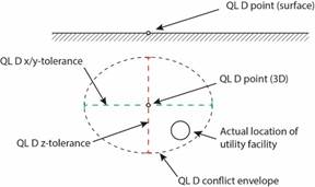
Figure 1.
Cross Section of Utility Facility Within Conflict Envelope
Literature Search Summary
STAs are
increasingly using 3D project design and modeling techniques during highway
design, for example Building Information Modeling (BIM) tools or 3D CAD tools.
Designing in three dimensions allows automated clash detection using a conflict
envelope around existing and planned facilities. This conflict envelope (or
“zone of influence”) is defined by the expected variability of the depicted
underground facility, which is information that is not readily available to
designers (Figure 1). This research is intended to help define the conflict
envelope for a variety of utility facility types.
• ASCE 38/02
• Kevin Vine. Subsurface Utility
Engineering (SUE): Avoiding 4 Potential Pitfalls to Ensure a Successful
Program. Paper Prepared for the Presentation at the Utilities Management - Past
Present Future Session Of the 2014 Conference Transportation Association of
Canada (TAC) Montréal, Québec.
• Michigan Utility Coordination
Committee’s Geospatial Utility Infrastructure Data Exchange 2014 Pilot.
• Michigan Department of Transportation
Road Design Manual.
Research Objective
This
research will aid designers in answering the question “How close can I design
to an existing facility?” As such, the research will assess utility records
versus test hole data or SUE QLA data to determine statistical accuracy for
risk-based SUE need determination, which will greatly aid project
practitioners. The research will generate statistics for use by designers and
project managers to make risk-based decisions regarding the need for SUE on STA
projects, and to be input into a BIM model for use in clash detection.
This
research will also identify and prioritize other risk factors to be used to
automate risk-levels. Some of these key attributes may include items such as
facility-owner, facility-type, age, facility dimensions, facility material,
installation method, existing record quality, etc. The research will also
develop a SUE risk matrix guidance document to recommend when and how to
implement SUE on a project. The research will address the following objectives:
• Develop guidance for STAs to
determine when to involve a SUE consultant after the STA has collected utility
information originating from various sources.
• Perform a statistical analysis of
record project utility location data versus actual locations to define
conditional risk-based envelope matrices that are dependent upon known project
conditions (to be identified during the research.)
• Determine whether it is feasible to
develop an algorithm that can predict the need for SUE that varies as a
function of the deviation from the “3D Point (QLD)” based on results of the
statistical analysis of actual location (QLA) vs records (QLD).
• Develop a risk matrix for obtaining
the proper SUE Quality Levels within areas of a project.
• Develop a Scope of Work SUE
checklist.
Urgency and Potential Benefits
Contractors
working on STA project around the country employ multiple mechanisms to protect
themselves from poor utility data provided within construction plans. All
states now have a one-call statute in place whereby the contractor must call
all known utility owners before construction begins. Utility owners then have
the burden of marking their utilities on the ground surface for damage
prevention purposes. Many times, the paint marks indicating the location of the
utilities do not agree with the utilities depicted on the design plans.
Contractors know this will happen and typically increase their bid price to
account for this contingency. They will also ask for change orders and claims
when necessary. Usually the project owner is obligated to pay these change
orders and claims due to utilities being treated as a differing or unknown site
condition in the standard contract documents.
STA implementing a process of determining if SUE is required earlier in
a project will only reduce contractor risk.
There are
numerous benefits for a risk based SUE guidance process on highway projects. By
using SUE, significant benefits are derived for the DOT, utility companies, SUE
consultants, contractors, and the general public. Some of the benefits that
have been obtained are as follows:
• DOT Quality: electronic mapping
accuracy, concept of a comprehensive SUE process, improved risk management,
improved project productivity and quality, minimize environmental damage;
• DOT time savings: less unforeseen
utility conflicts, relocations, delays due to utility cuts, elimination of
duplicate surveys;
• DOT Cost savings: lower project bids,
lower project contingency fees, project design less conflict redesign, claims,
change orders, Right-of-Way acquisition costs, and lowered insurance;
• Public Benefits: reduced motoring
public travel delays during construction, less damage to existing pavements,
less utility customers' loss of service, less traffic disruption, increasing DOT
confidence;
• Stakeholder benefits: reduced utility
companies' cost to repair damages, improved working relationships with
utilities;
Implementation Considerations
The use
of inaccurate utility data contributes to billions of wasteful spending in the
U. S. caused by utility and highway coordination. With few exceptions, the
public bears the cost of utility delays in form of traveler costs, added
transportation costs in retail products, loss of business efficiency (resulting
in higher costs and lower profits), and fewer public dollars available to spend
on a variety of project needs. With the advantages of 3D design and BIM being
explored at STAs, this research is imperative to analyzing conflicts with
improved confidence in the associated risks.
Recommended Research Funding and Research
Period
The
estimated cost is $350,000 and duration is 18 months. The research will complete the following
tasks:
1. Review related literature, including
best practices in SHRP2 products RO1A, R15B & ASCE 38.
2. Survey stakeholders, including STAs and
consultant design firms.
3. Identify STAs with utility record data
and or SUE QLA data available for analysis and request data.
4. Examine STA data and develop
appropriate statistical models.
a. 100 data points per facility type
sourced from case studies, for gas lines, water lines, underground electric
lines, and communication lines.
5. Analyze STA data using statistical
models.
6. Develop draft guidance documents.
7. Conduct an exploratory workshop to
collect feedback on draft guidance documents.
8. Refine and finalize guidance documents.
Note: The
research should have a focus on sharing information with potential bidders with
the goal that utility risks during construction are better understood,
potentially lowering construction bids.
Problem Statement Author(S): For each author,
provide their name, affiliation, email address and phone.
Alexis
Kinter, PE, PMP, Michigan DOT Metro Quality/Contracts , KinterA@michigan.gov
Potential Panel Members: For each panel
member, provide their name, affiliation, email address and phone.
Bill
Jackson, Maryland DOT Assistant Statewide Utility Engineer, Office of
Construction
wjackson2@mdot.maryland.gov
Person Submitting The Problem Statement: Name, affiliation,
email address and phone.
Rob
Martindale, PLS, Utilities Program Manager, II, Colorado Department of
Transportation
Rob.martindale@state.co.us